Research
We are interested in understanding processes and developing techniques for imaging and characterization of the part of the upper part of the Earth's crust that man can reach with boreholes. The EEG group is investigating all areas of applied geophysics from acquisition to processing, modelling and inversion for exploration and environmental problems. Although the main focus is on the seismic method, other techniques are also well covered.
Currently, the group's research is mainly focused on the following areas:
Modelling, inversion, and theory
Immersive Boundary Conditions

Immersive Boundary Conditions (IBC's) dynamically link wave propgation between multiple domains. We use IBC’s and other related wavefield injection boundary conditions in wide range of applications including local wavefield recomputation, hybrid modeling, seismic data processing, absorbing boundary conditions and to link physical and numerical modeling in the Wavelab.
Joint inversion
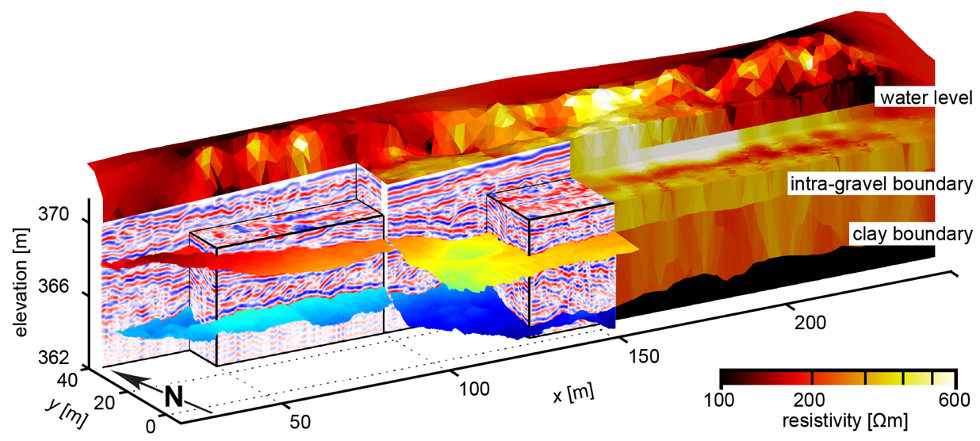
Minimally invasive geophysical methods provide images of subsurface physical properties such as seismic velocity and electrical resistivity, but these geophysical properties are only indirectly related to the required geological and engineering attributes (e.g., lithology, porosity, permeability). By using complementary information contained in different geophysical data types, joint inversion can help characterize the geological features of interest and aid in establishing rock physics models for quantitative analysis and enhanced interpretation. More on joint inversion.
Marchenko imaging
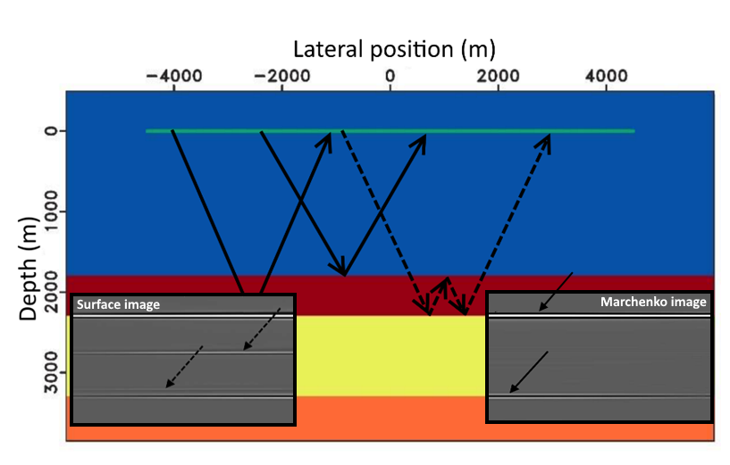
Marchenko redatuming allows us to redatum seismic surface data to an arbitrary new depth level within the subsurface. The input for this novel redatuming technique are the same as those required by standard imaging methods, namely the reflection responses with sources and receivers at the acquiring surface and an estimation of the background velocity model. Using an iterative Marchenko scheme and multidimensional deconvolultion, we are able to create redatumed reflection responses for sources and receivers at the new datum level for a medium that is equivalent to the actual medium below the new datum and homogenous above the redatuming depth. Marchenko redatuming has the advantage that internal multiples are reconstructed correctly and thus, the effect of a complex overburden can be removed effectively. Therefore, Marchenko redatumed data can be the starting point for many applications, such as target oriented imaging and velocity analysis. We investigate both, possible applications of Marchenko redatumed data and the influence of approximations and assumptions inherent in the Marchenko scheme to improve this redatuming method and to examine its applicability to real seismic data.
Full waveform inversion
Seismics is one of the main methods for obtaining subsurface properties. However, in the case of land seismic experiments the recorded data is very complex to the extent that in many cases none of the conventional methods is able to give reliable subsurface images. This complexity of the recorded waves comes from absorption, multiple scattering and other nonlinear effects in the near-surface zone. Thus it is necessary to take into account the full complexity of the subsurface in order to derive reliable tomographic reconstruction from such data sets. Full waveform inversion (FWI) has the potential to produce sub-wavelength resolution images. We develop new methodologies of FWI and apply them to real world problems such as non-intrusive monitoring of radioactive waste repositories (external pagehttp://www.modern2020.eu).
Cryosphere geophysics
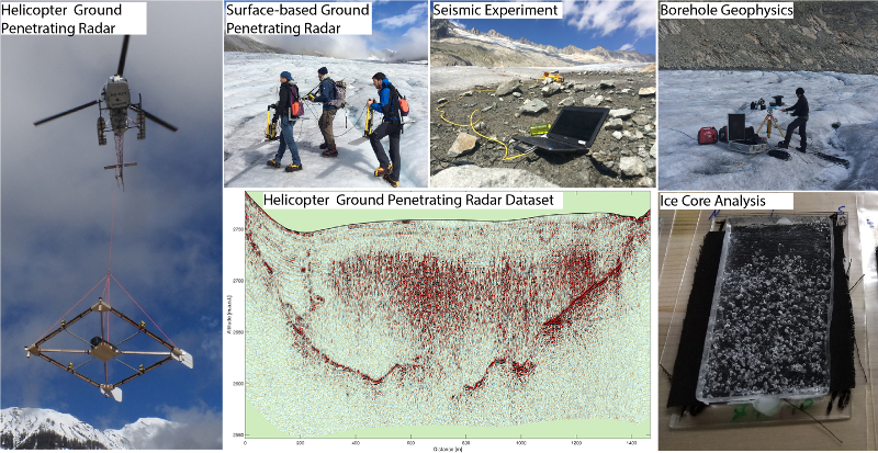
The cryosphere (e.g. glaciers, permafrost and sea-ice) changes rapidly under the impact of global warming. Mountain glaciers represent a critical resource for freshwater supply and hydropower energy. Clearly, these features are of high societal importance. Involved processes are governed by the physical properties of glaciers, either within the ice mass or at the glacier bed, which are often not directly accessible. The EEG group develops new geophysical measurement and processing techniques to characterize the internal structures of the cryosphere with a minimum effort and on largest scales possible.
Presently the main focus is on:
- Surveying of glacier thickness, glacier bed-geometry using helicopter ground penetrating radar (GPR).
- Comprehensive 3D characterisation of basal conditions and englacial features within a temperate alpine glacier using seismic and surface based GPR.
- Investigating temperate glacial ice properties through borehole geophysical analysis (borehole seismic and GPR) and ice core drilling.
Past studies involved characterization of alpine block glaciers using geoelectrical, seismic and radar methods or the determination of sea-ice thickness and water content using surface nuclear magnetic resonance and electromagnetic induction. The EEG group works in close collaboration with the glaciology division of ETH Zurich. More on cryosphere research within the EEG group.
Data acquisition methods
Simultaneous source acquisition
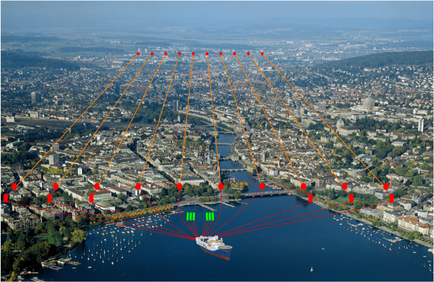
Simultaneous source techniques are a powerful tool to significantly improve the efficiency of seismic acquisition. While simultaneous source techniques are already used on land, novel techniques are required to bring the same benefits to marine seismic acquisition. We develop new source separation and source encoding methods, which will enable the acquisition of source-gradient data and offer numerous benefits for source-side techniques and seismic imaging.
Wavefield gradients
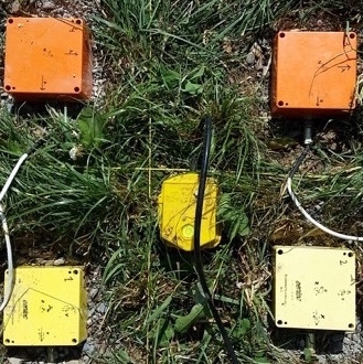
Spatial seismic wavefield gradient data provide complementary information to traditional multicomponent seismic data as they allow for a more complete representation of the wavefield. Seismic gradient and rotation data open up new possibilities to process land- and sea-bed seismic data. Applications include wavefield separation, near-surface characterization and noise suppression. We are working on instrumental developments, methodological advances and applications to field data. Similar techniques have been applied to the analysis of the Apollo 17 lunar seismic profiling experiment (LSPE) data.
Centre for Immersive Wave Experimentation (CIWE)

A novel center for seismic wave experimentation is currently under construction in the group of Exploration and Environmental Geophysics. The center comprises various physical laboratories for the investigation of complex acoustic and elastic wave phenomena as part of the WaveLab and MATRIX projects. More information can be found here.
Characterization of geothermal reservoirs
Survey design
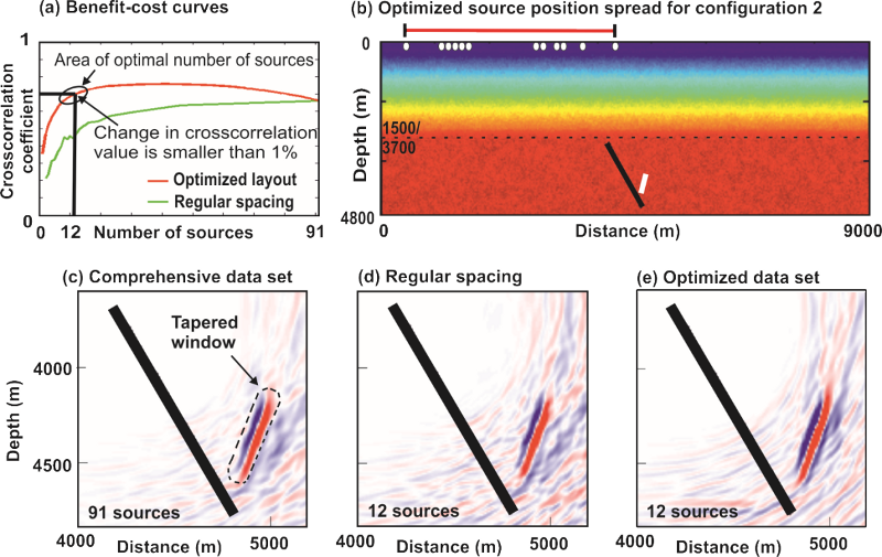
In the framework of the FP7 project external pageIMAGE, we have developed novel techniques to optimize the acquisition of vertical seismic profiling (VSP) data and improve the subsurface imaging with VSP. For example, our newly developed optimized experimental design strategy allows planning VSP surveys in a cost-effective way while taking the particularities of seismic geothermal exploration into account.
Rock physics
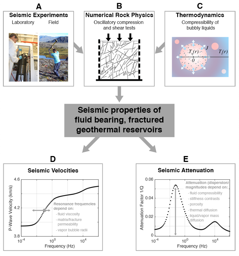
The permeability of the host rock and the energetic state of the saturating fluids are the main factors controlling the quality of geothermal reservoirs. By combining experimental techniques at various scales with numerical rock physics, we are investigating how seismic parameters are linked with these key factors. Such relationships are needed to interpret seismic reflection and travel-time tomograms acquired for geothermal exploration.
Monitoring cap rock integrity for CO2 storage
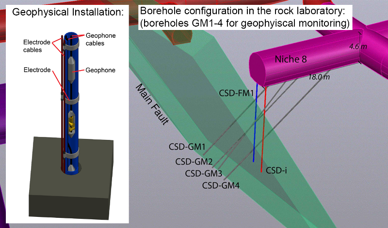
Confirming the permanent containment is a key challenge for the storage of CO2 in deep underground reservoirs. Faults in the cap rock of such reservoirs are considered to be a potential path for the CO2 to escape. In the frame work of external pageSCCER-SoE and the EU/SFOE funded project external pageELEGANCY, we use geoelectric and seismic methods to monitor the propagation of CO2-enriched brine along the main fault in the external pageMont Terri rock laboratory. The geophysical tools comprise time-lapse tomographic imaging of electric conductivity and seismic velocity changes during injection, as well as passive monitoring of potential micro seismic events.
Mars InSight Mission (SEIS)
The InSight (Interior Exploration using Seismic Investigations, Geodesy and Heat Transport) mission to Mars is a NASA Discovery Program mission planned to place a single geophysical station on Mars. The Mission’s aim is to study the deep interior of Mars and to address the most fundamental questions of planetary and solar system science: understanding the processes that shaped the rocky planets of the inner solar system (including Earth) more than four billion years ago. Read more here.